
IAF Mi-17V5 Helicopter Crash: What Is HTAWS And Why It Is Need of The Hour
Lack of risk awareness and underestimating weather can lead to catastrophic outcomes, writes Group Captain MJ Augustine Vinod (Retd)
India has lost many soldiers like General Bipin Rawat to Controlled Flight Into Terrain (CFIT) crashes. HTAWS could be the panacea for this persisting problem.
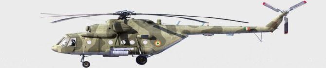
Many lives have been lost and many air crashes have happened due to a menace called Controlled Flight Into Terrain or CFIT (sometimes pronounced see-fit). This happens because the helicopter inadvertently enters IMC (Instrument Meteorological Condition), like it possibly happened with the Indian Air Force’s helicopter Mi-17V5 which was carrying General Bipin Rawat and 13 others. Now that I have introduced readers to terms like CFIT and IMC, let’s understand them clearly.
Controlled Flight Into Terrain
Controlled Flight Into Terrain (CFIT) is an air accident in which fully serviceable and fit aircraft is unintentionally flown into the ground, water or an obstacle. Accidents where the aircraft is out of control at the time of impact is called UFIT, but these are rare. CFIT accidents happen due to Loss of Situational Awareness (LOSA), more often than not due to weather and when the aeroplane’s position is especially close to the ground. But CFIT accidents are not limited to these conditions alone. Many CFIT accidents have taken place on flat or rising terrain as well. Furthermore, studies show that half of CFIT helicopter accidents took place in clear weather conditions. These statistics demonstrate that CFIT is caused by more than just weather conditions. It is actually LOSA which causes these crashes.
Historically, low visibility coupled with night/fog/clouds in mountainous terrain is the major cause of CFIT in helicopters. In helicopters, flying is mostly done visually; such is the nature of helicopter flying because of its design and the altitudes in which it flies. In most cases, CFIT happens while conducting an approach to landing. Aggravating reasons sometimes could be minor/major failures, like navigational system failure or even an engine failure.
Aeromedical aspects too could contribute to CFIT. False horizon, flying with cold (which could affect semi-circular canals in your ears that keep you upright) to tumour in your brain (yes, there was a crash on December 29, 1972 of a brand new flight of Eastern Air Lines Flight 401). Helicopters operate at much lower altitudes and weather minimums than airplanes. Which is why a helicopter pilot is always on the ball, all the time looking for exit routes, in case of failures.
What Is Inadvertent IMC
Visual Flight Rules’ (VFR) flights are those which are conducted with visual means, not only to fly but also to navigate. However, sometimes, an aircraft (fixed-wing aeroplane/helicopter) Inadvertently enters Instrument Meteorological Conditions (IIMC), before pilots get an opportunity to transit to instruments and operate rest of the flight under IMC (Instrument Meteorological Condition). When a helicopter pilot encounters such a situation he is (should be) trained to act in an appropriate manner to extricate from the situation. Pitfalls of IIMC are continuing with VMC (Visual Meteorological Conditions) in IMC conditions and not transitioning to instruments, while placing priority on loss of time or additional expense of a diversion or flight delay (sometimes referred to as “get-home-itis”).
Lack of risk awareness and underestimating weather can also lead to catastrophic outcomes. Sometimes, a pilot may sense a strong responsibility of reaching destination at all costs, which too can lead to the pilot not taking action on time. Sometimes passengers, especially if he/she is a VIP, may apply pressure and pilots may succumb to it.
Helicopter Terrain Awareness And Warning Systems (HTAWS)
The West has made Helicopter Terrain Awareness and Warning Systems (HTAWS) mandatory for helicopter emergency medical services (HEMS) and offshore operations flights. This is because of the disproportionately high CFIT crashes.
HTAWS computes precise three-dimensional position and velocity of the aircraft in real-time, monitoring corelates with accurate databases of the terrain height and hazardous obstacle locations. HTAWS automation continuously monitors the terrain/object and warns the pilot of the impending CFIT. It gives both warning and, if not heeded, clear-cut executory calls to pilots like “Pull – up, turn right, left etc.” Similar system is there in fixed-wing aeroplanes, including passenger aeroplane made by Airbus and Boeing, called EGPWS (Enhanced Ground Proximity and Warning System). Since the mandatory fitment of EGPWS, there have been few cases of CFIT in passenger aircraft.
Is HTAWS The Need of The Hour?
HTAWS would provide the following, which would reduce cases of CFIT in helicopter considerably:
1. Integrated three-dimensional (3D) visualisation, displays, sensors and database components2. High-resolution terrain imagery3. Sourcing of multiple specialised databases for airports, obstacles and terrain4. Improved proprietary high-accuracy data5. Helicopter-specific alerting algorithms6. Forward-looking terrain and obstacle-avoidance capability7. Visual and aural advisories (including voice alerts about relative conflict threat level), designed for helicopter pilots and their mission profiles8. Integration of HTAWS data with 3D synthetic vision system, traffic-alerting and collision avoidance system, weather radar and a separate obstacle warning system9. Height-above-terrain voice callouts at pilot-selected height ranges10. Pilot-selectable modes for minimising/suppressing nuisance alerts (enabling low-level operations and off-airport landings while allowing protection from terrain and obstacles)
India has lost many soldiers like General Bipin Rawat, politicians like YSR Reddy to CFIT in helicopters. HTAWS could be the panacea for this persisting problem.

