China Completes Pangong Tso Bridge, Now Making Road To Link Tibet Garrison, Satellite Images Show

China has been steadily building up infrastructure along the Pangong Tso lake area since 2020
Bridge will cut down 180-km loop from Chinese-held Khurnak to south bank via
PLA garrison. Built to counter operations like Indian Army's capture of
dominating heights in 2020.
New Delhi: China has completed the construction of a strategic bridge over
Pangong Tso on territory it holds in Khurnak, the narrowest part of the lake
that straddles Ladakh and Tibet. It’s now building roads to connect this to
one of its biggest military garrisons in the region, the latest satellite
pictures show.
In January this year, the Indian defence and security establishment had found
that a bridge was being built with pre-fabricated structures over the northern
part of Pangong Tso.
Sources had said that this was being built to counter any future moves by the
Indian Army on the lines of its August 2020 operation, which led to the
capture of dominating heights on Pangong Tso’s southern banks.

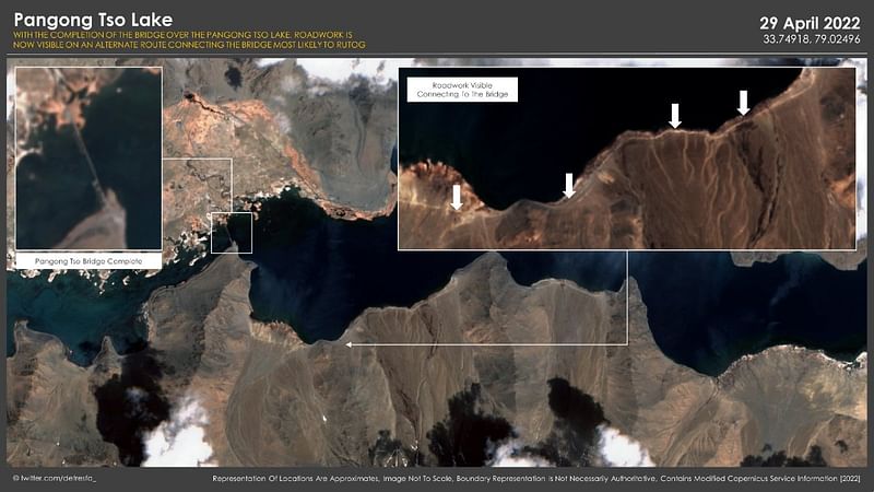
The latest satellite pictures show that construction of roadworks has begun | Twitter | @detresfa_
The bridge, which was completed in the first week of April, will cut down a
180-km loop from Khurnak to the south banks through Rutog county in Tibet,
where the People’s Liberation Army (PLA) has an important garrison.
The latest satellite imagery of the locations shows that the Chinese have now
also started road construction work.
Satellite imagery expert Damier Symon, who is popularly known by his Twitter
handle @detresfa_, put out the picture stating that road works have begun to
join the bridge most likely to Rutog, to ensure that Chinese soldiers can move
in quickly.
Further developments to the new Chinese bridge at #PangongTso, recent imagery shows roadworks have begun (as mapped in the quoted tweet) to join the bridge most likely to Rutog, giving #China's PLA troops in the area quicker connectivity through the terrain https://t.co/xLDhDTefvL pic.twitter.com/ELwWr6xE1N
— Damien Symon (@detresfa_) May 2, 2022
The PLA had earlier initiated road cutting from the bridge, and the road will
add to a new route for faster deployment of soldiers and materiel.
Explaining why the Chinese were building the bridge, a source in January had
said, “They have probably learnt the lesson and since they are quick in taking
remedial measures, multiple steps have been initiated to ensure that their
movement through that area is quicker and have the ability to scale up
presence in a big way”.
Infrastructure Build-Up
While the stand-off was on in the southern banks of Pangong Tso, between
September 2020 and mid-2021, the Chinese had built a new road to the Moldo
garrison to circumvent the visibility arc of the Indian soldiers and equipment
on top of advantageous heights.
China ramped up its infrastructure build-up along the Line of Actual Control
(LAC) even during the stand-off. This included the construction of new roads,
surface-to air-missile sites, heliports, and dwellings among others.
India, too, has carried out infrastructure build-ups along the LAC with the
construction of new roads, tunnels, underground ammunition depots, and the
induction of new warfighting equipment.


No comments:
Post a Comment