Atmospheric Re-Entry of Military Spy Satellite RISAT-2

RISAT-2, or Radar Imaging Satellite-2 is a reconnaissance satellite that is part of India's RISAT program. It was built by Indian Space Research Organisation (ISRO) and successfully launched aboard a PSLV-CA launch vehicle at 01:15:00 UTC on 20 April 2009 from the Second Launch Pad at the Satish Dhawan Space Centre, SHAR.
The principal sensor of RISAT-2 was an X-band synthetic-aperture radar (SAR) from Israel Aerospace Industries (IAI). It is designed to monitor India's borders and as part of anti-infiltration and anti-terrorist operations. The satellite has a mass of 300 kg (660 lb). Indian Air Force in association with ISRO operated the satellite.
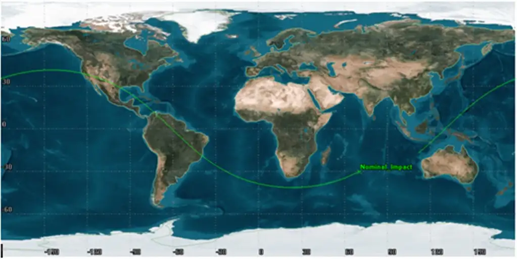
RISAT-2 was launched on 20 April 2009 by PSLV-C12 launch vehicle in an inclined eccentric orbit of 41.2deg inclination with Perigee altitude 400 Km and Apogee altitude 550 Km. Weighing only about 300 kg, the satellite has now made an uncontrolled re-entry into the Earth’s atmosphere at the predicted impact point in Indian Ocean near Jakarta on 30th October 2022 00:06 UTC with an uncertainty of ±10 minutes
RISAT-2 Satellite carried 30 Kg fuel for an initial designed life of 4 years. With the proper maintenance of orbit and mission planning by the spacecraft operations team in ISRO, by economical usage of fuel RISAT-2 provided very useful payload data for 13 years. Since its injection RISAT-2’s radar payload services were provided for various space applications. On re-entry, there were no fuel left in the satellite and hence there are no contaminations or explosion by fuel is expected. Studies confirmed that the pieces generated due to aero-thermal fragmentation would not have survived re-entry heating and hence no fragments would have impacted on Earth.
Indian System for Safe and Sustainable Space Operations Management (IS4OM) facility in ISTRAC/ISRO had been monitoring the re-entry for the last one month with analysis carried out by VSSC and ISTRAC teams through its in-house developed analysis software and tracking the object utilizing Multi Object Tracking Radar (MOTR) at SDSC, Sriharikota. MOTR tracked RISAT-2 regularly and the data were used for further analysis and Orbit determination. The orbital data available from USSPACECOM were regularly used to predict the re-entry time and impact.

It can be seen that near to the re-entry epoch, prediction became better and better. Final ground trace showed in Figure 2, clearly indicate that impact is in Indian Ocean.![]()
RISAT-2 is a clear example of ISRO’s capability to carry out spacecraft orbital operations in an efficient and optimal way. As RISAT-2 re-entered within 13.5 years, it complied with all necessary international mitigation guidelines for Space Debris, showing ISRO’s commitment towards long term sustainability of Outer Space as well.


No comments:
Post a Comment